Tuesday, September 27, 2016
The Many Paths of Curriculum
Broadly speaking, traditional methods courses like TE 407 and TE 408 are divided into three broad areas: curriculum (the what of teaching), instruction (the how of teaching), and assessment (how we know they learned what we taught).
Throughout the year, we will consider each of these three areas in some depth. But as you no doubt noticed, as we have started the year, we have given our greatest attention to curriculum.
Defining curriculum as “the what of teaching” works for everyday purposes. But it is also helpful to step back and think about curriculum in its broader meaning. The origins of the word come from the Latin, currere, which means “to run.” Its meaning was eventually extended to the track or course on which one runs. Curriculum can therefore be thought of as a journey—as the journey one takes throughout life.
In the state of Michigan, as in the rest of the world, there is content that is assigned to each year of the schooling experience. For the past twenty-five years or so, this content has been organized into learning standards. Michigan’s newly proposed standards for k-12 social studies can be found here.
When teachers plan their instruction, they begin by consulting the relevant curriculum documents. These include standards documents and the local textbook that is assigned to your course.
What we have been practicing is the art of gathering multiple types of resources (written, visual, online, etc.) that can be used to teach the required content in a way that is both engaging and inclusive of multiple perspectives. But gathering is only the first step!
For it is how we ask questions that “pull out” all that a resource offers that is the true art of teaching. Indeed, one of the most important resources for your students is you! Think about how you can maximize the unique talents you bring to the classroom.
It is a question of how we can open up a space in which thinking and feeling and caring can happen.
Ultimately, as we leave this first unit of TE 407, we want you to understand that all of life has the potential to become curriculum. Indeed, as we prepare to assist Ben and the other teachers from Haslett Middle School on their field trip tomorrow, it is a great time to remind ourselves that true learning happens when the learner is able to organize their life experiences so as to go on growing in the future.
Our job as teachers is to learn how to take advantage of whatever the school day brings—a textbook reading, a guest talk from Mike Lupica, a lockdown drill, a school dance, or a field trip.
Great job through our first unit of the year! Andrew and I look forward to reading your curriculum resource assignments, which are due up on your website by Wednesday, October 5.
TE 407 Course Resources: September
Here are links to the course syllabus, the curriculum resource assignment, and the Michigan Social Studies standards.
TE 407 Syllabus
Curriculum Resource Assignment
Michigan Social Studies Standards
Google Earth Tours Presentation Schedule
Teaching in Ben's Class Schedule
TE 407 Syllabus
Curriculum Resource Assignment
Michigan Social Studies Standards
Google Earth Tours Presentation Schedule
Teaching in Ben's Class Schedule
Monday, April 4, 2016
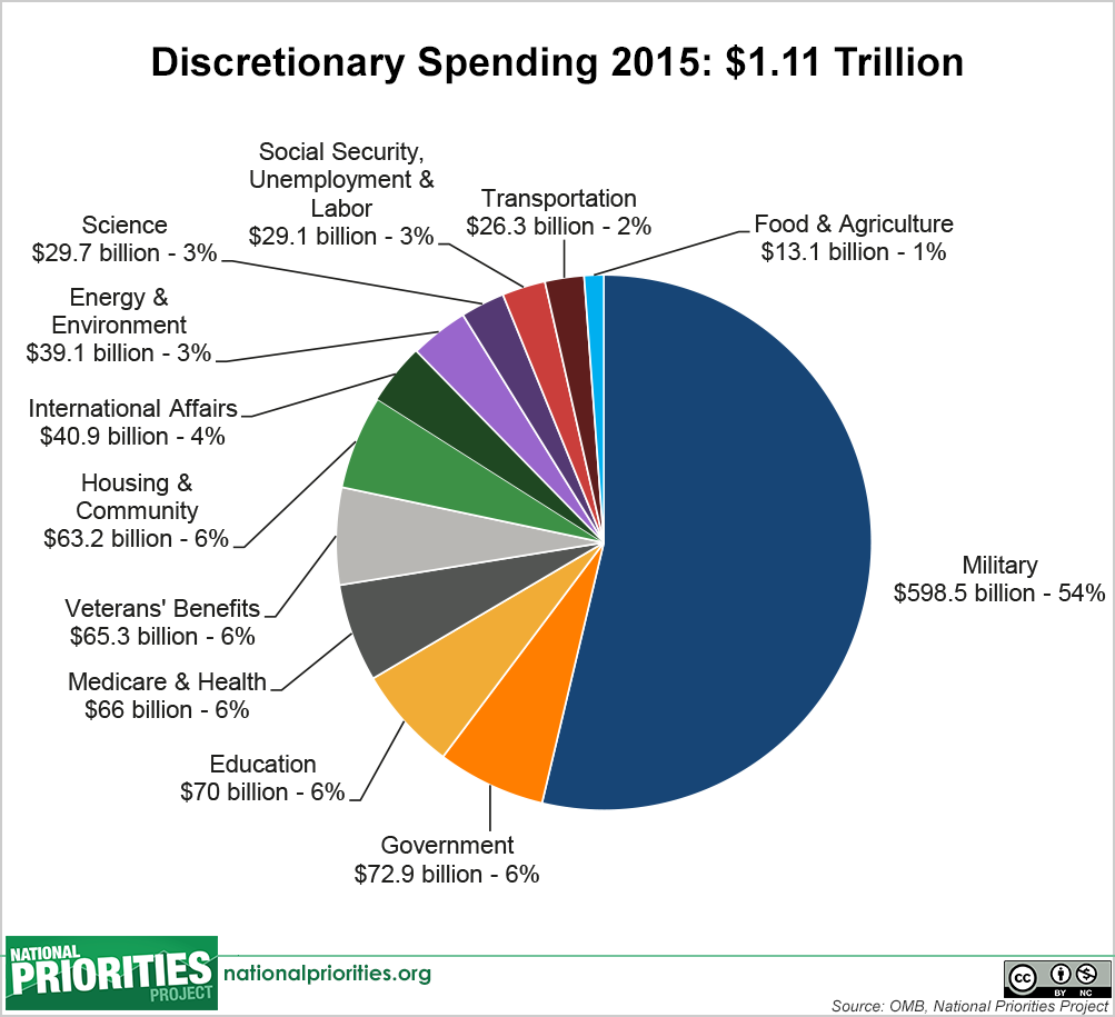
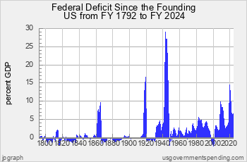
Teaching With Economic Data
Get
into microteaching groups. Each group will receive one graphic. Your job is to
be ready to jigsaw into teaching groups on Wednesday. You will use both
discussion and direct instruction to teach your graphic. Each group will have
up to fifteen minutes to teach their graphic and the issues related to it.
Monday, February 15, 2016
Geographical Inquiry
Today, we thought about maps as texts that organize information spatially from a particular vantage point. Each part of this definition seemed important as we worked through what it is we might do with the maps we share with students: focus on the data and information that is presented, look at it in its spatial distribution, and think about the vantage point of the map projection.
In NatGeo Mapmaker, we got to play around with the spatial distribution of different variables. Of particular interest is when we could create a map that yielded information on the spatial relationships between two or more variables. This allows us to raise questions about geographic determinism (see this article by Jared Diamond). What does it mean if social violence or poverty is especially concentrated in the tropical areas of the world? Are there any geographic features that explain this? How do geographic features such as climate and landforms influence societies? How important are such geographic factors as we try to make things of why things are where and why they are?
In Worldmapper, we looked at cartograms as tools that allow us to look at the distribution and location of different variables as they interact with territorial size. This was an excellent tool for teaching kids to generate hypotheses, bring to bear background knowledge that would inform the hypotheses, confirm or disconfirm our hypotheses through the cartogram, and then to ask what other information would be necessary to further understand what it is we are seeing.
In Google Earth, we saw how we can create spatial tours that integrate picture, text, and satellite imagery. As a spatial alternative to PowerPoint, such tours allow us to share and present information through spatial frameworks. (Here is a cheat sheet for some of the things we did in class today.)
Monday, January 25, 2016
Simulation Review
In your assigned groups, look at
your assigned simulation-type activity. Start to read, evaluation and discuss
the materials. Then consider:
· What would you need to do in order to help students learn
from this activity?
· What you would do to set up this activity and how you could
extend it once it was over?
· In class on Wednesday, you will have be asked to engage the
class in 10 minutes of the simulation.
Tuesday, January 19, 2016
World History Lecture Notes
World History Standards for Grade 7
1) Disciplinary Skills and Processes
2) Study of Specific Eras
o WHG Era 1 – The Beginnings of Human Society
o WHG Era 2 – Early Civilizations and Cultures and the Emergence of Pastoral Peoples
o WHG Era 3 – Classical Traditions, World Religions, and Major Empires
o WHG Era 4 – Expanding and Intensified Hemispheric Interactions
3) Final Project
4) Integration of Other Disciplines
High School World History Standards
1) Study of Specific Eras x Lens/Frames
o WHG Era 5 – The Emergence of the First Global Age, 15th to 18th Centuries
o WHG Era 6 – An Age of Global Revolutions, 18th Century-1914
o WHG Era 7 – Global Crisis and Achievement, 1900-1945
o WHG Era 8 – The Cold War and Its Aftermath: The 20th Century Since 1945
2) Final Project on Contemporary Issues
3) Social Studies Processes and Skills
In order to think about our units and lessons, we therefore have to have a process for drawing upon diverse standards across multiple areas of the document. In general, we want to integrate:
a) Global patterns, inter-regional interactions, and regional case examples
b) Essential research and literacy skills in the discipline
c) Concepts and connections from other social studies disciplines
What are ways that we can do this?
1) Plan units that are focused on an era, but that that have an essential question that links to another discipline.
o Examples:
§ Did the agricultural revolution solve or invent food scarcity? (history integrated with economics)
§ Did the agricultural revolution promote equality or inequality? (history integrated with government)
2) Make sure to integrate projects and activities into every unit that emphasize aspects of the inquiry arc (where students examine primary and secondary sources, make claims, and write narratives that evaluate agency, motive, and cause/effect).
3) Use regional case examples to illustrate global trends.
4) Look for moments of inter-regional “historical convergence”: trade, migration, war, empire, and cultural and technological diffusion.
TE 408 Course Documents
Here are links to course documents you will need this semester:
TE 408 Course Syllabus
Formal Lesson Plan Assignment
Objective Test Assignment
Formative Assessment Assignment
TE 408 Course Syllabus
Formal Lesson Plan Assignment
Objective Test Assignment
Formative Assessment Assignment
Subscribe to:
Posts (Atom)